
Builders of the REM and the city will be putting together an intricate bike path linking TMR to Ste-Anne-de-Bellevue and Deux Montagnes.
Article content
Cycling advocates say a planned bicycle network will become like a highway for cyclists and make it much more efficient to get around the island by bike.
The city is forging ahead with plans to build a so-called véloroute, to connect at least 15 of the stations on the eventual REM light-rail network and link to employment hubs and nature parks. The véloroute will span at least 38 kilometres of Montreal Island and link to Laval and as far as Deux-Montagnes. The network will link to existing bike paths as well as industrial parks and nature parks, like Cap St-Jacques, les Bois-de-l’Île Bizard and the future Grand parc de l’Ouest.
Advertisement 2
Article content
Article content
Construction is set to begin at the end of the year and will last until 2032.
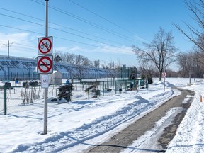
The network will be built alongside the REM’s tracks on the two branches heading toward Ste-Anne-de-Bellevue and Deux-Montagnes, starting at Canora Station in Town of Mount Royal.

“We hope this will allow Montrealers to have new mobility options in the face of known congestion in the areas affected,” Sophie Mauzerolle, the executive committee member in charge of mobility, said in a written statement. “Stimulating active transport while rolling out this bike network will improve accessibility to 15 stations of the REM, improve access to employment hubs and decongestion in certain key areas all the while creating links to nature parks.”
Magali Bebronne, a program director at the cycling lobby group Vélo Québec, said the project could be a game changer for people who commute to work by bike. She said if it’s planned correctly, this will allow cyclists to access a huge swath of protected bike lanes that are separated from car traffic and uninterrupted by stop signs or traffic lights. Currently, there are very few spots where cyclists can travel significant distances separated from cars and without major interruptions from traffic signals. Among those the examples are a three-kilometre path at Des Carrières St. in Rosemont—La Petite-Patrie and a 2.1-kilometre path at Souligny Ave. in Mercier—Hochelaga-Maisonneuve.
Advertisement 3
Article content
“It’s rare to have such long stretches that would be uninterrupted and allow people to travel long distances,” Bebronne said. “It also creates a redundancy, in the event that the (REM light-rail) system breaks down.”
She said the West Island is an area where it is especially difficult to commute by bicycle, and the network will make it easier not just for cyclists in the area to commute downtown but also within their local neighbourhoods. While the distance from the network’s extreme points to the downtown core are ambitious for most cyclists, Bebronne believes it would be a boon for those with electric bicycles.
Those who take the entire path will also be able to link to bike paths that would take them downtown or several other parts of the central city. The network would also allow cyclists to access the city’s métro network, as it would come close to the Côte-Vertu and Du Collège stations on the Orange Line.
The first hurdle to build the network was cleared in January when Montreal’s agglomeration council and the city of Montreal approved two borrowing bylaws worth more than $90 million. The money will be used to study the project, purchase the land necessary and build the network itself.
Advertisement 4
Article content
The provincial government will also contribute to the project, so the overall price tag isn’t yet known. Some of the project could also be subsidized by higher levels of government, according to the loan bylaw approved in council.
However, it is still not clear who will do the work, as much of the land is owned by CDPQ Infra, the infrastructure arm of the Caisse de dépôt et placement du Québec, which owns and operates the REM. The Autorité régionale de transport métropolitain is also involved in the planning.
Recommended from Editorial


The concept was first conceived in 2012 by the St-Laurent borough as a way of linking the then-Deux-Montagnes train tracks to the Bois-de-Liesse nature park. At the time, the borough asked the agglomeration to build a bike path alongside the entirety of the line. In 2016, a small 1.4-kilometre section of the path was built to link Toupin Blvd. to the Bois-Franc station as a test area.
“It was a part of an overall plan to have that type of biking infrastructure, but the arrival of the REM means that parts of the véloroute were put on hold because the CDPQ bought the Deux-Montagnes rail line,” said St-Laurent borough mayor Alan DeSousa. “They didn’t think it would be safe to have two construction sites at the same time.”
DeSousa welcomes the idea, even if his borough asked the agglomeration council to put this bike network together in 2012. He said the planning will be done over the next few months by elected representatives from the boroughs and cities along the route.
“It will take some co-ordination to make sure the trajectory works for the interests of their residents,” DeSousa said. “We need to make sure there is a coherency there.
“I think the benefit of this is to do it as much as possible within the corridor, with as few impediments as possible so those who use it can fly without having to do the stop-and-go that you normally encounter in city traffic.”
DeSousa said he’s optimistic that the project will get off the ground as planned, saying there is a lot of political will to make it happen, and because the work on the tracks has been completed by the REM’s builders.
Advertisement 5
Article content
Article content